Subscribe
60°

Heavy Rain, Strong Winds To Ramp Up As Slow-Moving Nor'easter Pummels Region: Update
A powerful Nor’easter battering the Northeast this weekend is far from finished.
The massive storm is expected to bring more rounds of drenching rain and dangerous winds, toppling limbs, threatening power lines, and making travel risky Saturday evening, Sept. 26, into Sunday, Nov. 27.
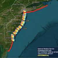
The National Weather Service said that the slow-moving storm will also continue bringing coastal flooding, high surf, and dangerous rip currents through the weekend. The greatest impacts are near the coast.
During the day Saturday, tens of thousands of customers lost power, with New York, New Jerse…
Massive Nor'easter Slams East Coast: Thousands Without Power, When Conditions Will Worsen
A sprawling Nor'easter has moved into a critical phase, with the worst conditions still building.
Click here for a new, updated story - Weekend Nor’easter: Wind Cited As Major Concern In Updated Forecast
The National Weather Service said Saturday, Sept. 26, that the system will continue to produce significant coastal impacts along the Eastern Seaboard through Monday, Sept. 28. Major coastal flooding, damaging wind gusts, heavy rain, rough surf, and beach erosion are forecast.
AccuWeather’s forecast for Saturday, Sept. 26, highlights strong coastal winds, coastal flooding, beach erosi…
Nor’easter Takes Aim: What To Do Now Before Conditions Worsen, Power Outages Strike
The best time to prepare for a dark home is before the lights go out.
The National Weather Service recommends stocking essential supplies before a storm disrupts power, communications, or access to stores. Its preparedness checklist offers practical steps as the weekend Nor’easter approaches.
AAA Northeast also urged residents Friday, Sept. 25, to prepare their homes, vehicles, and travel plans for wind, rain, and coastal flooding, according to its emailed news release.
Related report - Nor’easter Nears, Power Concerns Mount: Who Faces Highest Risk
Start with supplies that work wit…
Multi-Threat Nor'easter Update: Dangerous Winds, Heavy Rain, Big Waves Could Last Days
A days-long, multi-threat Nor'easter is set to bring heavy rain that could cause flooding and damaging winds that could cause power outages, stretching from the Carolinas to Cape Cod.
Click here for a new, updated story - Nor'easter Threat Grows: Where Rain, Wind Will Hit Hardest
The National Weather Service warned Wednesday, Sept. 23, that southern New England faces a prolonged stretch of rain, strong winds, and coastal flooding beginning Friday, Sept. 25. Trees still carrying their leaves increase the concern for wind damage.
Cape Cod and the islands could see gusts approach…
Power Outages Soar Past 100K After Severe Storms Slam Pennsylvania Again
More than 100,000 homes and businesses were without power across Pennsylvania on Friday, Sept. 4, after another round of severe storms brought destructive winds, torrential rain, flooding, and tornado warnings.
Approximately 102,700 customers remained in the dark Friday morning, more than twice the 43,000 reported Thursday morning and five times Wednesday afternoon’s total, according to PowerOutage.us.
The latest storms shifted the heart of the outage crisis to western Pennsylvania. The hardest-hit counties included:
Westmoreland County: 42,045 outages.
Allegheny County: 20,667 outages.
C…
More Winter Weather Alerts Issued In NJ, PA As Tuesday Storm Aims At Morning Commute
Winter weather alerts have been issued across North Jersey and eastern Pennsylvania ahead of Tuesday’s storm, which is expected to bring several inches of snow and slippery roads during the morning commute, according to the National Weather Service.
A Winter Storm Watch is in effect for Sussex County, where 4 to 7 inches of snow and snowfall rates of up to 1 inch per hour are possible.
Winter Weather Advisories have been issued for Hunterdon, Morris, Warren, and Western Passaic counties, forecasters said.
In Pennsylvania, winter weather advisories cover Berks, Lehigh, Northampton, Upper Bu…